Search
Close this search box.

Pre-decommissioning surveys

Navigating the intricate challenges of decommissioning offshore assets demands precision and expertise.

Efficient, comprehensive and precise

We empower you with the most efficient, comprehensive and precise view of your subsea infrastructure, along with industry-leading insights and reporting, to facilitate informed decision-making.

Unparalleled situational understanding of the condition of structures

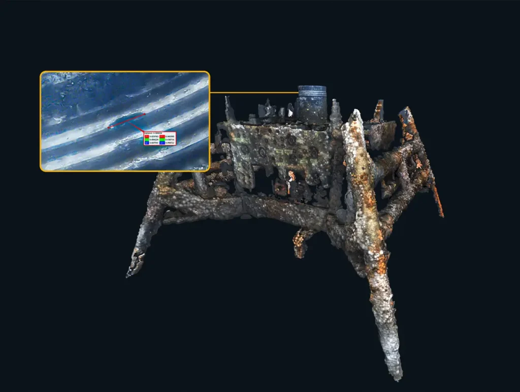
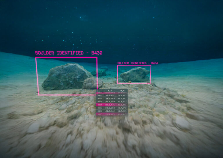
Subsea Asset condition is often unknown, or uncertain, which can result in expensive re-engineering work and schedule delays when “as found” has diverged from “as planned”.

Using SubSLAM 3D imaging technology, Beam can provide accurate 3D models of subsea infrastructure, which otherwise may be undocumented, or exhibit deviations or environmental degradation versus the available design definitions.

Ensuring effective decommissioning with precise structural insights

Our detailed inspection solutions provide an unparalleled situational understanding on the condition of structures, allowing validation of engineering plans, prior to mobilisation of personnel and equipment.

This ensures planned decommissioning works are achievable and effective, providing a greater certainty on cost and schedule.  Aborting operations as a result of unforeseen problems can be very expensive and time consuming.

Real-time 3D visualisation & modelling

Generate colour 3D models in real time while performing visual inspections. Perform continuous data capture; no pre-survey installations, no need to stop and scan, no contact measurement tools.

The models have sub-millimetre precision and can achieve accuracies of 0.1% – 0.15% (as verified by Bureau Veritas), providing a true physical representation of subsea environments and structures. 3D models can be used to verify the condition of subsea assets and compare against prior measurements or design definitions.

The live 3D point-cloud viewer presents a persistent coverage map for real-time verification that the required information has been collected, meaning no data gaps and no costly return trips. Take live measurements in the viewer and export the real-time model instantly. Accelerate photogrammetry using SubSLAM’s exported stereo-scaled image pairs to achieve even higher resolution 3D models with post-processing.

SubSLAM also supports integration with external INS systems to output models in georeferenced coordinates for precision location and onwards integration of data in digital twin environments.

Our added value

  • Verify integrity of primary structures, including lifting points and their condition.
  • Take contactless measurement of critical dimensions to ensure that tooling is appropriate.
  • Perform volumetric analysis of marine growth coverage to confirm that true lifting loads are within specification for planned lifting equipment and vessels.
  • Detect and action the removal of debris appropriately, without unnecessarily tying up high-value assets.

A breadth of capabilities

Our specialist skills and knowhow have been hard-earned through challenging projects in the harshest environments. This has deepened our understanding of what technology is truly capable of, enabling us to deliver exceptional insights with speed and efficiency.

Downloads

Explore our collection of specification sheets and brochures to gain a deeper understanding of our technology and the services we provide. Download now to discover how our expertise can support your needs and drive your success.

View our latest news and highlights

Press Releases